X-Plane has been lacking a decent navigation solution for general aviation aircraft for a long time. The built-in GNS430 instrument could only do direct-to navigation and not use X-Plane’s FMS plans, making long IFR flights inconvenient.
In X-Plane 10.30 we are introducing a new generation of the X-Plane 430 GPS navigator, modeled more closely after the Garmin 430W that is very popular in general aviation aircraft. The 430W is a popular aftermarket GPS replacement in many older general aviation aircraft, because it is approved for WAAS approaches and thus an easy upgrade to allow flying instrument approaches at lots of smaller airports without ILS.
The new X-Plane unit can create and fly multi-leg flightplans in addition to the direct-to function:
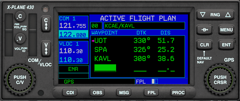
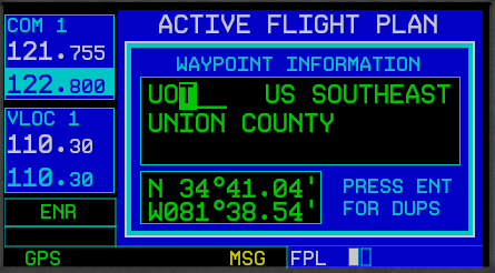
You can create directs or flight plans using a worldwide database of airports, fixes and navaids:
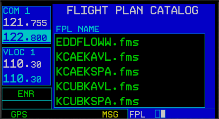
Loading or saving the route works using the X-Plane FMS format. Many online services for virtual flight planning are compatible with that:
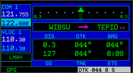
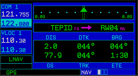
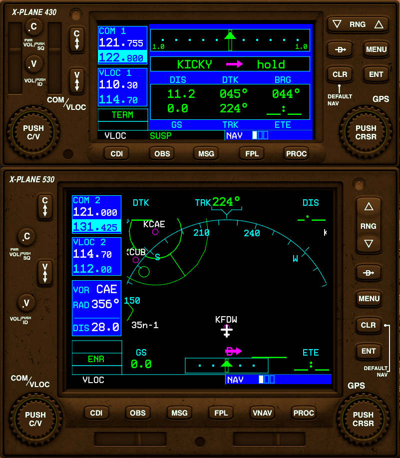
You can then navigate along your flight plan using one of different map views that provide situational awareness:
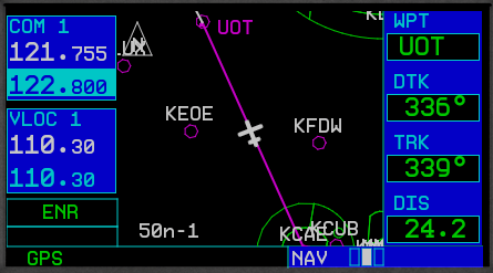
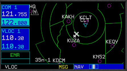
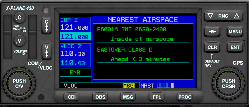
While flying under VFR, stay alert to any Bravo, Charlie, Delta or special use airspace in the United states (open database, user-expandable):
You will be warned when you are about to violate an airspace:
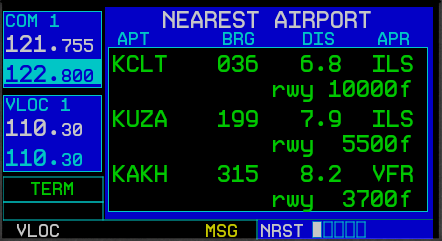
using the nearest airport function you always know your nearest alternatives for landing (though we all know X-Avion does a much better job at that!)
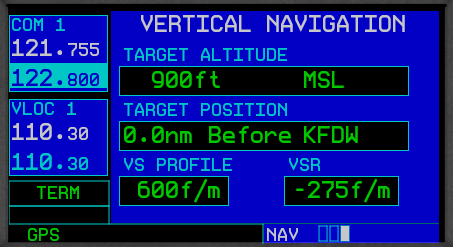
With a little help from your friend, knowing when to start your descend becomes easy:
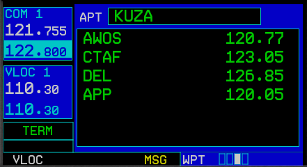
Before landing, always know who to call:
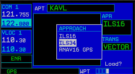
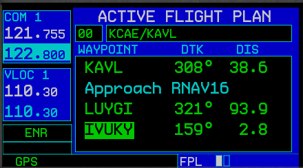
For IFR approaches, load precision and non-precision approaches from a world-wide, updatable database:
Review approach transitions and initial approach fixes:
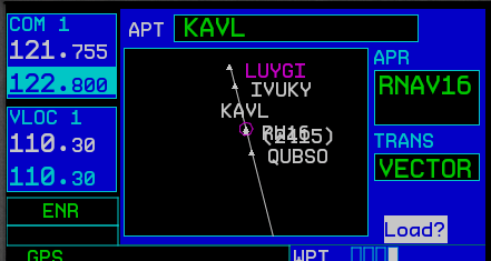
and then load any approach and transition into your flight plan:
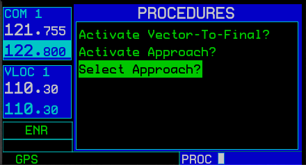
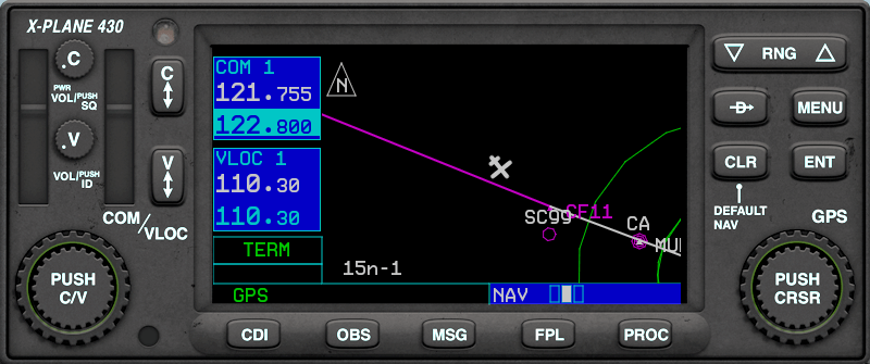
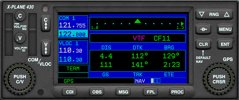
Under ATC (read: when flying online) the vector-to-final function will often be used instead of a transition:
The X-Plane 430 is there to help you stay alert to common errors in approach navigation:
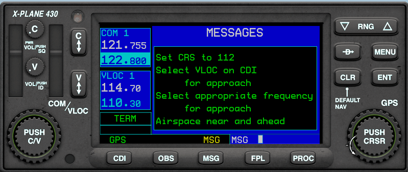
The GPS is capable of flying non-precision GPS-approaches with a localizer-like guidance and varying CDI sensitivity:
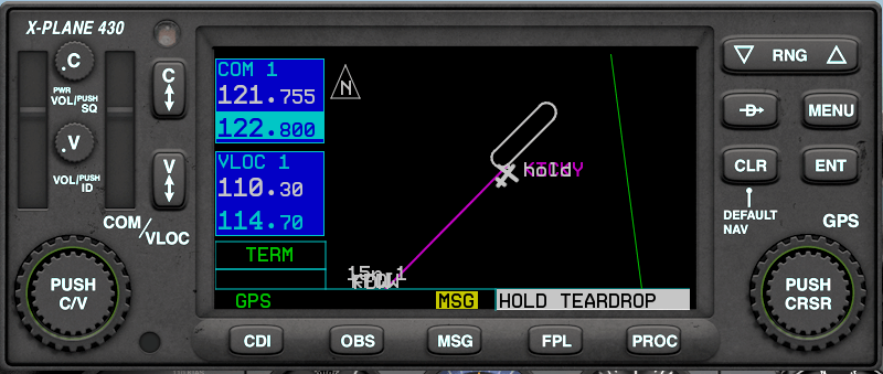
If you don’t see the runway at the minimum descend altitude, continue to the missed approach point and the flight plan sequencing will go into suspend. At the missed approach point, if you still don’t see the runway, begin your missed approach:

and then get help choosing the right entry to the missed approach holding:
The new GNS430 is a drop-in replacement for the old one, so every X-Plane aircraft equipped with the GNS430 automagically becomes more IFR-capable with the 10.30 update. We also provide an additional instrument in style of the bigger GNS530, that designers can use in their aircraft starting with Plane-Maker 10.30. It also allows for dual installations that can either use separate flight plans or cross-fill.
The interaction of the GPS with the rest of the panel, especially the CDI and the autopilot, has been improved, offering a few more options for aircraft designers. Two additional posts explaining the new options in Plane-Maker will follow shortly.
The database from which approaches are loaded is provided by Aerosoft. A current database will be provided once with X-Plane 10.30, and further updates will be available on a subscription basis.
You might have noticed stupid COM frequencies in some screenshots. This is not a bug, but a feature: X-Plane 10.30 supports 8.33kHz channel spacing, that is now mandatory in the European upper airspace and will become more important over the next few years.
For the inevitable question “will it have X and does it simulate Y?” I do have one answer:
I chose the feature-set for the 10.30 release carefully to fulfill two requirements:
- It must simulate the functions I use every day. After spending about 40 hours flying a C172P with this equipment, I have developed some pattern in day-to-day use. The simulated equipment must have the functions I use every day.
- It must simulate what I need for my IFR checkride preparation. I’m currently studying for the instrument rating. All IFR GPS functions that are needed during the lessons must be simulated so I can use X-Plane to practice at home.
This does not cover all functions of the real unit, but it covers what the pilot absolutely needs every day.
You say the navdata updates will come from Aerosoft, but some of us use Navigraph instead, does Navigraph have a format that’s compatible?
Technically yes. The format is very common and compatible. I can’t speak for the administrative side of that though.
I assume the subscription will only be necessary for approaches, while other parts still work on the data already maintained at http://data.x-plane.com/ (which by the way appears to be a few months behind), correct?
You are totally correct.
Fantastic Ben, this is a great improvement!
Keep up the wonderful work!!
Dom
Awesome,
awesome,
awesome.
Bring it on…..
PLEASE!
Sorry, I should have said Philipp!!
My apologies.
Dom
Fantastic news ! Thanks a lot !
Do we have an eta on 10.30 beta ?
I’ll post a bit on 10.30 scheduling in a few days.
Note a programmer’s day is an epoch of time roughly equivalent to a day on Venus.
As a retired captain in the marine instrustry I can honestly say this is long overdue but extremely welcomed. Now stop horrsing around and get to work..:)
Hello Philipp,
this is awesome news! As I was enjoying RXP 530W on FSX very much with it’s near 100% features (lacks simulation of realistic satellite coverage; RAIM etc)—I wonder which are the features you chose to leave out?
This is yet another USP for GA enthusiasts. Thanks and congrats!
/Jonas
This is going to be a serious tool — much better than the FSX default GPS, wow! Hopefully, in the v11 time frame, we can get somewhat deeper ATC too…not everyone flies online, nor is coverage always available. This shows that XP is a serious tool!
hope this will lead the way to another overdue improvement, atc.
it’s now been 2.5 years of waiting 🙂
Outstanding! Definitely long overdue!
A little known feature (but incredibly important for IFR flight) is the ability to change fields on the first NAV page. I normally fly with the BRG field replaced with XTK (cross track error). This tells you exactly how far you are, laterally, from the the desired course. This is a must-have for enroute navigation. Here’s a video of it in action: https://www.youtube.com/watch?v=z02TeOzgMGE (look for the XTK field on the top right where BRG used to be).
Phillip, wow !!! That’s look very nice!
I think, it will the end of my time with the KLN90B, sniff !
Best greets
This is so great. Better visibility and distance rendering… and now this… Christmas… 🙂
It feels like Christmas or a birthday !
Nice to see you posting here, Philip. I wasn’t aware that you were now working “under the hood” so to speak, but given your long history of X-Plane contributions, it’s about time!
This is cool stuff. The big question I have is: how much of the core underpinnings might be exposed by dataref for use by third party applications like XHSI? More current and complex Planemaker instrumentation is always nice, but for those of us building cockpits it’s the code behind them that really excites.
Not yet. Currently the main goal is to maintain compatibility with all existing external plugins. New functions might be added in a future SDK update.
Thanks for the major upgrade. It will greatly improve realism with XP-10. I am looking forward to the new release. Keep up the good work.
Nice work, Philipp. This is perhaps the beginning of the beginning.
Wonderful!! Really promising!!
Is the Aerosoft database usable/upgradable for us Linux users?
I have looked at the NavDataPro before only to find:
Windows XP, Vista, 7, MacOS10.5 or higher
Or is the 430W going to use a seperate Aerosoft database?
The database is just a bunch of text files. Aerosoft could provide them in a zip if you can’t use their program I guess.
RT @XPlaneOfficial: Dev Blog Post: New approach-capable GPS navigator in X-Plane 10.30 http://t.co/DkuhiNOn74 #xplane
That is AWESOME!
Great job! Congrats!
From developers view, are you going to provide extra commands/datarefs that cover all this functionality?
All buttons and knobs on the gps can be triggered via commands. Some new datarefs were added to cater for the possibility to have two units in one panel now.
Brilliant, wonderful, fantastic, amazing news.
After the great news concerning visibilty and cloud improvements (shadows too?) the GPS is the icing on the cake. This positivity has brought me back to XP with a smile on my face after a couple of months flirtation with the “other” sims!
Not a showstopper, but if you get time guys, please kill the constant screeching tyres when taxiing. 😉
Any chance Arrivals and Departures will be added to the Procedures page?
Maybe later. Especially STARS are seldomly flown as filed anyway. They are also quite boring from the IFR training point of view, not much going on there. Approaches, with stuff like the sensitivity adjustment going on in the background are a lot more exiting and important. That’s why they are a priority, while procedures that are only “flight plan cosmetics” usually overridden by ATC anyway are not.
New approach-capable GPS navigator in X-Plane 10.30 – http://t.co/RmFiheltKF
One question: Will there be a sound for the buttons or will we have to make a callback for every command?
No button in X-Plane panels/default instruments makes a special sound. I don’t think there should be one exception for one instrument.
Early X-Plane 10 betas had a click feedback sound, people didn’t like it, so it was removed around 10.05 I guess.
This is very cool, also a bit off topic, I heard that you guys showed off XP10 running on an Occulus Rift at this weekend’s Aerosoft conference. Hopefully some video of the show will escape on to the Web.
Aerosoft took pictures, and the german PC Games Hardware magazine made a video. That might surface on youtube. I’ll post a link if they post it.
photos and videos here (only in German unfortunately): http://www.pcgames.de/Special-Thema-215651/Specials/12-FlightSim-Konferenz-in-Muenchen-Besuch-auf-der-Flugsimulatormesse-1115579/
Would Developers have to update their aircraft (Like Carenado) or will the instruments just be automatically be updated when you open X-Plane 10 in beta10.30?
Great new feature for X-Plane, no doubt about that… well done. The GNS1000?
We are looking for a drop-in seemless integration and are working with developers like Carenado to make that as easy as possible.
Phillip, will the inside area of screen be the same from old instrument?
I don’t understand this question. The old instrument is replaced by the new instrument. What do you mean with “inside of the screen”?
The lcd screen, I’ve mapped it to a 3D object on my models, will the screen still match the old positions?
Yes, that will continue to work.
Additionally, we offer resizeable screen-only 430/530 instruments you can use in 3d.
Great News! Since IFR hopefully gets more common in Europe due to the new enroute IFR (EIR) rating this new 430 rocks. You may have all G1000 in the USA but here in Germany the 430 is the most common nav.
For the total luck I would just love to see an iPad App covering the haptics of the 430.
There was mentioned that airspace data will be user-expandable? Then again you say that you use Aerosoft data which is subscription based? I would like to know if it would be possible to enter custom airspace data to it and perhaps share the information with ithers freely. Something like standard X-Plane nav database update?
Approach data comes from Aerosoft.
Airspace data uses a very well-known open-source format. You can find tons of free airspace definitions for about any country in the world here: http://soaringweb.org/Airspace/ We are trying to reach out to these guys so we can compile and ship a close to worldwide database from these files. Those issues are legal issues, not technical issues. You can drop in any airspace file in the format known as “openair for winpilot”.
Fantastic news! When I started using XP 10.25 a couple months ago, I spent HOURS reading the Garmin 430 manual, only to find out that the stock GPS didn’t perform like the real-life “TOY” does! This will make flying SOOOO much easier!
Right Matt, from “toy” to “tool”
I’ll be curious how to tune all those waypoints in—so tedious with the current knob systems. Maybe AirFMC can jump in and give us a way to do this on our iPads. Although it sounds like we could program and save using the FMC and then import later?
Exciting addition.
My bad. Just saw Phillip’s comment:
“All buttons and knobs on the gps can be triggered via commands. “
Philipp, this is excellent news!
Next step (beside the SDK), an upgrade for the default FMC?
Marc.
SDK is more important. With that you could build your own FMC I guess.
Hi Philipp, This is wonderful news !
As a cockpit builder it would be very nice if we could run the new Garmin 430 in a separate “floating” window in high resolution on the same monitor as X-Plane or move the G430 to another compact LCD display which could be touchscreen or a hardware solution from Emuteq.
http://www.emuteq.com/GNS530.html
Keep up the excellent work !
Same screen yes, external touchscreen no. I wholeheartedly recommend FTS if you need that functionality.
Is there any way we get a proper ATC back like in version 9?
It’s progress like this, that makes me glad I switched to X-Plane
Looks very nice!! Just wondering if there will be a pop-up capability with the new panel, and if so, could this be mapped to a joystick button and/or hot-key? This would be very useful for folks who have built home cockpits and therefore don’t utilize the 3D cockpit instrument panels rendered in the sim.
Definitely.
Great news everyone! 🙂
Well done!
That good news. Clearly, this is another big step for X-Plane.
Congratulations guys!
“All buttons and knobs on the gps can be triggered via commands.” Perhaps this is a silly question… Will this new 430/530 allow data entry via the keyboard, i.e. enter waypoints? Thanks in advance.
I’ve no definitive answer to that yet, as I just hated the way the “keyboard grab” worked in FSX. It would grab your keyboard whenever the GPS cursor was set to enter a waypoint. Which drove you crazy when you forgot the cursor was active, and suddenly all your keyboard commands didn’t work anymore. If I can come up with a simple, unobtrusive solution I’ll add that.
It would IMO be very useful to have a pop-up display of such complex units that can grab the keyboard. It’s way fiddly and unintuitive to manipulate them with the mouse, always hunting for the hotspots that might also be moving due to cockpit “bob” or because someone is using TrackIR. That concept somewhat works with simpler units like the standard radios, but something as intricate as a GPS with several buttons and knobs, some of the latter coaxial, and all with an additional function on push, needs a way to operate separate from the general cockpit rendering.
On a real unit, you’d steady your hand by putting a finger somewhere as a reference, you have a lot of tactile feedback, buttons require a higher push force than the average mouse, and you can make use of a relatively fixed reference in the cockpit and muscle memory. All that goes out the window in a 3D cockpit of a sim.
“If I can come up with a simple, unobtrusive solution I’ll add that.”
How about how you handle it in the B752’s FMC? A click region (or keystroke) that toggles keyboard inputs with a little ‘k’ to denote the mode is on.
I find it a nightmare to manually scroll through the letters to enter airport names on the current GPS unit; keyboard input would be hugely helpful!
It might be something like that, but remember: in the Boeing FMC it is always obvious where your input goes: it goes into the scratchpad. The gps doesn’t have a scratchpad, so it’s less obvious what is going to happen if you start typing.
I see you said WAAS support. Does this allow for LPV-type GPS approaches with vertical guidance?
No vertical guidance yet, as the navdata is currently lacking one field that is necessary to get the final descend to the MDA right.
Apart from that, the logic for LPV is already in, including the angular-type CDI sensitivity when switching from TERM to LPV.
niiice!
will the xp’s ‘map’ receive a complete overhaul as well ?
the what xplane is missing is a decent map moving feature …
No, the moving map is not yet updated.
“Yet” so there are plans to update it ?
Moving maps with terrain can be done via plugin:
http://www.xsquawkbox.net/xpsdk/mediawiki/Category:XPLMScenery
Also SASL etc. support that
One thing that would be great for default AP from X-Plane would be to be able to fly-by or over-fly waypoints and be able to plot simple curved shapes in GPS mode.
But I don’t think you are up to this point now.
Would it be in roadmap one day?
Thank for the update, much appreciated work here!
Cheers
With the new 430/530 in the plane, the autopilot will do all that*. Fly-by, fly-over, and the map will plot the turn anticipation.
* if you select the correct type of autopilot in the new Plane Maker. We’ll have a post on that shortly.
OK,
but nothing for DME arc plotting then… (might be a bit too complex to implement it as GPS is point only…)
I would guess you would stick to GNSS type of procedure…
Would PRNAV also taken into account (some of those require DME ARC Approach procedures)?
Cheers !
All of the above is supported to be flown with and also displayed correctly by the 430.
This looks excellent. However, will it give correct distances to VOR stations when flying in the UK? The current offering shows me more than 3000 nm from Dean Cross VOR when I take off from Liverpool (I guess it should be about 100 nm), and I’m more than 3000 nm from the Edinburgh ILS when I’m moving along taxiway A in Edinburgh itself!
That sounds like you should cross-check your chart with the X-Plane map to make sure the frequencies of the navaids that you want to use agree.
They do agree, and they can be used just fine for VOR navigation. Moreover, if the aircraft has its own DME display, this shows the correct distance; for example, sitting at EGPH with NAV1 tuned to the airport’s ILS (108.90), the Carenado Bonanza’s DME display shows 0.3 nm, while the X-Plane GPS display shows 3361 nm, with an ETE of 641 and a DTK of 181 (despite the fact that the parking is on the south side of the airport).
With the current XP 430 there is no way to refresh the aircraft’s current position relative to the selected waypoint without “re-initializizing” the unit via the “Direct To” button and re-entering the waypoint. Aircraft equipped with the stock FMC, however, do allow a “one click” position refresh, allowing regular updates during the flight.
Question: Will the new 430/530 have such a “one click” refresh option?
If I remember correctly, the sequence for doing that is press the -D-> button twice.
Will give that go and report back. Thanks!
Sorry to report, for me at least, double clicking doesn’t do it.
I was talking about the new gps I made for 10.30.
Excellent!
Good news – your last image appears to indicate that the fault doesn’t exist in your new GPS. If I position my aircraft at KDFW with the NAV1 frequency shown in your image, the morse ID is CAE, and the aircraft’s DME display shows 28 nm, in agreement with your image. (The default GPS, on the other hand, shows 4960 nm to the VOR station, so it’s not just in the UK that it gets this wrong; moreover, the distance doesn’t even change when I change the frequency.)
Now I’m REALLY looking forward to this one. Thank you.
I look forward to the upgrade of the 430 GPS in the current aircraft in my hanger.
Are there any compatibility problems which would result from differences in the texture resolution used in existing cockpit panels and the texture resolution used for the new 430 instrument. Hopefully, the “snap-in” is meant to be truly automatic and would occur for current dual 430 cockpits also.
Good Work!
We are investigating that now. Generally speaking, if you have a 3-d cockpit and you have mapped the existing instrument (62 pixels tall) from the 3-d panel texture to that 3-d cockpit, it’s going to be hard to read in the 3-d cockpit, because the panel texture is too low res. That’s not something X-Plane can work around internally. We’re looking at the best compatibility options, and a user can always click on the small instrument to get the big clean popup version. We’ll post guidelines once we’ve found the best options.