X-Plane 11 Map API Sample
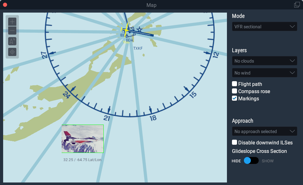
The sample below exercises the XPLM300 map layer API. Note that it depends on the image below (map-sample-image.png) being located in your X-Plane/Resources/plugins directory. If the image is missing, you will see a “missing resource” warning in your Log.txt file (and of course the icon drawing functionality of the map layer will instead draw nothing).

- Download as a project for Xcode 14 or newer (64-bit Intel)
- Download as a project for Microsoft Visual Studio 2017 (64-bit; requires Windows 8.1 SDK)
- Download as a project for GCC 4.x/Linux (64-bit)
#include "XPLMMap.h"
#include "XPLMGraphics.h"
#include <string.h>
#include <stdio.h>
#if IBM
#include <windows.h>
#endif
#if LIN
#include <GL/gl.h>
#elif __GNUC__
#include <OpenGL/gl.h>
#else
#include <GL/gl.h>
#endif
XPLMMapLayerID g_layer = NULL;
static int coord_in_rect(float x, float y, const float bounds_ltrb[4]) { return ((x >= bounds_ltrb[0]) && (x < bounds_ltrb[2]) && (y >= bounds_ltrb[3]) && (y < bounds_ltrb[1])); }
void createOurMapLayer(const char * mapIdentifier, void * refcon);
static void prep_cache( XPLMMapLayerID layer, const float * inTotalMapBoundsLeftTopRightBottom, XPLMMapProjectionID projection, void * inRefcon);
static void draw_markings( XPLMMapLayerID layer, const float * inMapBoundsLeftTopRightBottom, float zoomRatio, float mapUnitsPerUserInterfaceUnit, XPLMMapStyle mapStyle, XPLMMapProjectionID projection, void * inRefcon);
static void draw_marking_icons( XPLMMapLayerID layer, const float * inMapBoundsLeftTopRightBottom, float zoomRatio, float mapUnitsPerUserInterfaceUnit, XPLMMapStyle mapStyle, XPLMMapProjectionID projection, void * inRefcon);
static void draw_marking_labels(XPLMMapLayerID layer, const float * inMapBoundsLeftTopRightBottom, float zoomRatio, float mapUnitsPerUserInterfaceUnit, XPLMMapStyle mapStyle, XPLMMapProjectionID projection, void * inRefcon);
static void will_be_deleted( XPLMMapLayerID layer, void * inRefcon);
PLUGIN_API int XPluginStart(
char * outName,
char * outSig,
char * outDesc)
{
strcpy(outName, "MapPlugin");
strcpy(outSig, "xpsdk.examples.mapplugin");
strcpy(outDesc, "A test plug-in that demonstrates and exercises the X-Plane 11 map API.");
return 1;
}
PLUGIN_API void XPluginStop(void)
{
// Clean up our map layer: if we created it, we should be good citizens and destroy it before the plugin is unloaded
if(g_layer)
{
// Triggers the will-be-deleted callback of the layer, causing g_layer to get set back to NULL
XPLMDestroyMapLayer(g_layer);
}
}
PLUGIN_API int XPluginEnable(void)
{
// We want to create our layer in the standard map used in the UI (not other maps like the IOS).
// If the map already exists in X-Plane (i.e., if the user has opened it), we can create our layer immediately.
// Otherwise, though, we need to wait for the map to be created, and only *then* can we create our layers.
if(XPLMMapExists(XPLM_MAP_USER_INTERFACE))
{
createOurMapLayer(XPLM_MAP_USER_INTERFACE, NULL);
}
// Listen for any new map objects that get created
XPLMRegisterMapCreationHook(&createOurMapLayer, NULL);
return 1;
}
PLUGIN_API void XPluginDisable(void) { }
PLUGIN_API void XPluginReceiveMessage(XPLMPluginID inFrom, int inMsg, void * inParam) { }
void createOurMapLayer(const char * mapIdentifier, void * refcon)
{
if(!g_layer && // Confirm we haven't created our markings layer yet (e.g., as a result of a previous callback), or if we did, it's been destroyed
!strcmp(mapIdentifier, XPLM_MAP_USER_INTERFACE)) // we only want to create a layer in the normal user interface map (not the IOS)
{
XPLMCreateMapLayer_t params;
params.structSize = sizeof(XPLMCreateMapLayer_t);
params.mapToCreateLayerIn = XPLM_MAP_USER_INTERFACE;
params.willBeDeletedCallback = &will_be_deleted;
params.prepCacheCallback = &prep_cache;
params.showUiToggle = 1;
params.refcon = NULL;
params.layerType = xplm_MapLayer_Markings;
params.drawCallback = &draw_markings;
params.iconCallback = &draw_marking_icons;
params.labelCallback = &draw_marking_labels;
params.layerName = "Markings";
// Note: this could fail (return NULL) if we hadn't already confirmed that params.mapToCreateLayerIn exists in X-Plane already
g_layer = XPLMCreateMapLayer(¶ms);
}
}
int s_num_cached_coords = 0;
#define MAX_COORDS (360 * 180)
float s_cached_x_coords[MAX_COORDS]; // The map x coordinates at which we will draw our icons; only the range [0, s_num_cached_coords) are valid
float s_cached_y_coords[MAX_COORDS]; // The map y coordinates at which we will draw our icons; only the range [0, s_num_cached_coords) are valid
float s_cached_lon_coords[MAX_COORDS]; // The real latitudes that correspond to our cached map (x, y) coordinates; only the range [0, s_num_cached_coords) are valid
float s_cached_lat_coords[MAX_COORDS]; // The real latitudes that correspond to our cached map (x, y) coordinates; only the range [0, s_num_cached_coords) are valid
float s_icon_width = 0; // The width, in map units, that we should draw our icons.
void prep_cache(XPLMMapLayerID layer, const float * inTotalMapBoundsLeftTopRightBottom, XPLMMapProjectionID projection, void * inRefcon)
{
// We're simply going to cache the locations, in *map* coordinates, of all the places we want to draw.
s_num_cached_coords = 0;
for(int lon = -180; lon < 180; ++lon)
{
for(int lat = -90; lat < 90; ++lat)
{
float x, y;
const float offset = 0.25; // to avoid drawing on grid lines
XPLMMapProject(projection, lat + offset, lon + offset, &x, &y);
if(coord_in_rect(x, y, inTotalMapBoundsLeftTopRightBottom))
{
s_cached_x_coords[s_num_cached_coords] = x;
s_cached_y_coords[s_num_cached_coords] = y;
s_cached_lon_coords[s_num_cached_coords] = lon + offset;
s_cached_lat_coords[s_num_cached_coords] = lat + offset;
++s_num_cached_coords;
}
}
}
// Because the map uses true cartographical projections, the size of 1 meter in map units can change
// depending on where you are asking about. We'll ask about the midpoint of the available bounds
// and assume the answer won't change too terribly much over the size of the maps shown in the UI.
const float midpoint_x = (inTotalMapBoundsLeftTopRightBottom[0] + inTotalMapBoundsLeftTopRightBottom[2]) / 2;
const float midpoint_y = (inTotalMapBoundsLeftTopRightBottom[1] + inTotalMapBoundsLeftTopRightBottom[3]) / 2;
// We'll draw our icons to be 5000 meters wide in the map
s_icon_width = XPLMMapScaleMeter(projection, midpoint_x, midpoint_y) * 5000;
}
void draw_markings(XPLMMapLayerID layer, const float * inMapBoundsLeftTopRightBottom, float zoomRatio, float mapUnitsPerUserInterfaceUnit, XPLMMapStyle mapStyle, XPLMMapProjectionID projection, void * inRefcon)
{
// The arbitrary OpenGL drawing done for our markings layer.
// We will simply draw a green box around the icon; the icon itself will be enqueued when we get a callback to draw_marking_icons().
XPLMSetGraphicsState(
0 /* no fog */,
0 /* 0 texture units */,
0 /* no lighting */,
0 /* no alpha testing */,
1 /* do alpha blend */,
1 /* do depth testing */,
0 /* no depth writing */
);
glColor3f(0, 1, 0); // green
const float half_width = s_icon_width / 2;
const float half_height = half_width * 0.6667; // our images are in a 3:2 aspect ratio, so the height is 2/3 the width
for(int coord = 0; coord < s_num_cached_coords; ++coord)
{
const float x = s_cached_x_coords[coord];
const float y = s_cached_y_coords[coord];
if(coord_in_rect(x, y, inMapBoundsLeftTopRightBottom))
{
// Draw the box around the icon (we use half the width and height, since the icons will be *centered* at this (x, y)
glBegin(GL_LINE_LOOP);
{
glVertex2f(x - half_width, y + half_height);
glVertex2f(x + half_width, y + half_height);
glVertex2f(x + half_width, y - half_height);
glVertex2f(x - half_width, y - half_height);
}
glEnd();
}
}
}
void draw_marking_icons(XPLMMapLayerID layer, const float * inMapBoundsLeftTopRightBottom, float zoomRatio, float mapUnitsPerUserInterfaceUnit, XPLMMapStyle mapStyle, XPLMMapProjectionID projection, void * inRefcon)
{
for(int coord = 0; coord < s_num_cached_coords; ++coord)
{
const float x = s_cached_x_coords[coord];
const float y = s_cached_y_coords[coord];
if(coord_in_rect(x, y, inMapBoundsLeftTopRightBottom))
{
#define SAMPLE_IMG "Resources/plugins/map-sample-image.png"
if(coord % 2)
{
XPLMDrawMapIconFromSheet(
layer, SAMPLE_IMG,
0, 0, // draw the image cell at (s, t) == (0, 0) (i.e., the bottom left cell in the sample image)
2, 2, // our sample image is two image cell wide, and two image cells tall
x, y,
xplm_MapOrientation_Map, // Orient the icon relative to the map itself, rather than relative to the UI
0, // Zero degrees rotation
s_icon_width);
}
else
{
// Draw the image at cell (s, t) == (1, 1) (i.e., the top right cell in the sample image)
XPLMDrawMapIconFromSheet(layer, SAMPLE_IMG, 1, 1, 2, 2, x, y, xplm_MapOrientation_Map, 0, s_icon_width);
}
}
}
}
void draw_marking_labels(XPLMMapLayerID layer, const float * inMapBoundsLeftTopRightBottom, float zoomRatio, float mapUnitsPerUserInterfaceUnit, XPLMMapStyle mapStyle, XPLMMapProjectionID projection, void * inRefcon)
{
if(zoomRatio >= 18) // don't label when zoomed too far out... everything will run together in a big, illegible mess
{
for(int coord = 0; coord < s_num_cached_coords; ++coord)
{
const float x = s_cached_x_coords[coord];
const float y = s_cached_y_coords[coord];
if(coord_in_rect(x, y, inMapBoundsLeftTopRightBottom))
{
char scratch_buffer[150];
sprintf(scratch_buffer, "%0.2f / %0.2f Lat/Lon", s_cached_lat_coords[coord], s_cached_lon_coords[coord]);
// The text will be centered at the (x, y) we pass in. But, instead of drawing the label in the center
// of the icon, we'd really like the text to be shifted down *beneath* the icon we drew,
// so we'll subtract some amount from the y coordinate
const float icon_bottom = y - s_icon_width / 2;
const float text_center_y = icon_bottom - (mapUnitsPerUserInterfaceUnit * icon_bottom / 2); // top of the text will touch the bottom of the icon
XPLMDrawMapLabel(layer, scratch_buffer, x, text_center_y, xplm_MapOrientation_Map, 0);
}
}
}
}
void will_be_deleted(XPLMMapLayerID layer, void * inRefcon)
{
if(layer == g_layer)
g_layer = NULL;
}