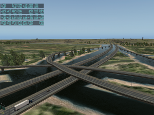
 When I saw this near KMSY in New Orleans my first thought was: oh hell, what bug created that? All of the roads seemed to run over these channels of water, as if someone had created mini-rivers for them. I assumed bad OSM data.
Then I looked the area up on Google and…no, they actually built the road over water intentionally.
Oh no… not a new rule for pylons! Just curious, is there a rule for pylons in overlaps?
Ironically that area was one of the bugs I reported with 10.05 due to the roads shooting up into the sky (KMSY is where I fly out of most often on VATSIM) and I actually said “perfect!” after seeing this!
Same here, Mike!
What’s the story when roads get submerged in the ground ?
That part of Interstate 10 goes over like about 30 miles of swamp. Drove though that area last year and that is exactly how it looks.
LMAO, that’s awesome! 🙂 Great work with the OSM data interpretation.
Speaking of OSM interpretation, is there any work being done in that area for the next releases ? I’m still missing my huge Ottawa River 🙂
I haven’t had time to get back to OSM yet.
Nice! That is the I-10 /310 intersection just outside Kenner, La. (AKA New Orleans, But not really) 1-2 miles north west of KMSY.
I am now going to check and see if I-10 over the Atchafalaya Basin, between Lafayette and Baton Rouge, is rendered like that!
So I flew over and checked out the Basin Bridge , between Lafayette and Baton Rouge, and the scenery is way off from what is really there. Only half of the entire stretch of the bridge is there. The water around that area show as land. But the road does not jet straight in the sky.