This summer Tyler migrated the X-Plane scenery SDK documentation to X-Plane’s main wiki. I just put in a series of redirects, so that the old URLs for the top level pages will point to the various wiki sub-categories. The wiki contains the most recent information now, as well as up-to-date download links, etc.
At some point I will try to replace the individual scenery documents (part of the library.php script) with redirects to the appropriate wiki pages; until then I will leave the old site in place.
Alpilotx pointed me toward a thread on the org discussing Austin’s work on the weather system. The thread turned into a bit of a he-said-she-said with regards to Outerra and whether it could some day be combined with X-Plane.
This blog post will be a discussion of various general approaches to scenery and the trade-offs we have to consider, e.g. plausibility and realism, procedural vs. algorithmic and data driven design. But first, a brief note on Outerra. As I have said before, we are already aware of Outerra, so there is no need to email us. The bottom line is that we have a set of mostly done features for X-Plane 10, our goal is to finish X-Plane 10, and we are not even spending one brain cell considering putting a new rendering engine into X-Plane while we are trying to get 10.0 done.
Defining Some Terms
One of the problems with comparing scenery system approaches is that a real productized approach to scenery rarely fits into a perfect bucket or matches a single theoretical techniques. So here are some approximate terms, designed to generally describe an approach. They’re not going to be perfect fits, and even the definitions will fluctuate in different contexts and forums.
- We can say scenery is plausible when it looks like it might exist somewhere in the world. Plausible means that roads don’t go straight up over a cliff, trees don’t grow in the ocean, etc. In other words, plausible scenery is scenery where absurd things don’t happen. Plausible scenery is great when you don’t know what an area should look like. A lack of plausibility is often a bug.
- We can say scenery is realistic when it correlates closely with what is really present at a given location on the Earth. So if there really is a lake behind my house, realistic scenery has that lake. Plausible scenery might have a lake, a forest, or something else believable for where I live (the Northeastern United States). A giant sandy desert would not be plausible for my location.
- We can say scenery is procedural if the detail in the scenery comes from some kind of algorithm that produces results. For example, a fractal coastline is procedural.
- We can say scenery is data driven when the detail comes from some source of external input data. Our mountains are currently data driven – that is, the mountain shape basically comes directly from the DEMs we use.
- We can say scenery is artist driven if the look of the scenery comes from art assets created by an art team.
- We can say scenery is algorithm driven if part of its look comes from the transformational process that converts data from one form to another.
(I’m sort of drawing a line in the sand here with procedural vs. algorithmic, but what I’m trying to contrast is a program that generates ‘information’ out of thin air vs. a program that creates information out of other information. For example, in X-Plane 9, European capillary roads were procedural. We had no real data, so I wrote an algorithm that made them up in a manner that was consistent with underlying terrain. In version 10, these roads will be algorithmic; we take OSM data and then do some processing to make it suitable for X-plane. This is definitely a line in the sand kind of definition.)
So Are We Plausible or Realistic?
So the first question is: is the goal of X-Plane global scenery plausibility or realism? The answer is: a bit of both. Austin’s posts on the subject virtually always bring up plausibility. The reason for this is simple: he is not too worried about the amount of realism we’ve put into the scenery, but he is not happy with the bugs. He wants the bugs gone. So every time he and I speak, he says “and make sure it’s plausible!”
But we’re not going to remove realism just to fix plausibility bugs. I expect that the next global scenery render will be at least as realistic as the last – that is, we’re going to use better data and we’re not going to make up data where we had real information before.
There are limits to realism. We don’t expect the global scenery to ever be as realistic as a custom scenery package for a small matter. But realism does matter. Part of the joy of flying in a flight simulator is seeing the real world. Where we can have more realistic global scenery, we consider it to be a win, and we are always looking to be more realistic than the last render.
Plausibility for the version 10 render is going to take two forms:
- Bug fixes. Any time something screwy happens, it’s not plausible. Sometimes these are code bugs that must be fixed, and sometimes they are data conflicts. For example, the water data sasys “water” but the elevation data says “hill”. Combine them and you get water going up a hill. We have to write code to resolve this, somehow.
- We are reworking the way cities are rendered, because even at their best, the old approach, procedural buildings with algorithmic roads over land class photos, did not look plausible, even at its very highest setting. So this is a feature request to fix a plausibility problem.
Algorithmic or Procedural
I’ve discussed this before (and forgotten about the post). But to expand the discussion, we need to consider not only algorithmic and procedural data processing, but whether we are driven by procedural generation, input data, assets created by artists, or some combination. (In practice, all systems require a mix of data, art assets, and procedures and algorithms, it’s a question of the blend.)
I’ve been working on global scenery for a few years now, and over time I’ve come to appreciate the importance of artist input (via art assets) into any scenery process. Simply put, if you want scenery to look good, you need to make it reasonably straight forward for people who are good at making pretty pictures to control the look of your visual results. A few years ago I viewed the scenery process as strictly a question of data conversion and visualization, but now I see it as finding a way to merge art assets and data into a cogent final product, with the art assets being used in a way that the artists can control. In practice, this often means making sure that the art assets come in a format that artists are comfortable with or can learn without too much pain.
As I said in the previous post, our approach is becoming more algorithmic and less procedural as higher quality source data becomes available. (For example, we don’t have to generate European roads when we can import and reprocess them.) But our approach over time has always been heavily artist driven. By this I mean: our input data is algorithmically processed into a final form that makes sense only in the context of art assets, and we have a pretty good idea of what those art assets will look like when we design the algorithms. To use roads as an example again, our task with OSM is to convert OSM road data into a road network that will visualize nicely with road art assets created by an artist.
Procedural Compression
One way to view procedural scenery is “creating lots of information from little or no information”. But another wa
y to think of it is as a compression technology. As was correctly pointed out on the org forums, you use less storage specifying the overall location of a forest than you do specifying every tree individually. The compressed form (store the forest location) can be equally plausible. It will be less realistic if the original tree locations were based on real world data, but it will be equally (unrealistic) if the original tree locations were procedurally generated. Put another way, pushing procedural processes out of the scenery generation process and into the flight simulator makes DSFs smaller.
When I first started working on X-Plane 8 DSF scenery, not only was DVD size a factor, but so was load time; we had one core and it wasn’t a very fast core. Anything we could do to make loading faster, we did. Thus we pushed a lot of work into the scenery generation process, including procedural processes, to keep load time down.
Times have changed; we now have dual core machines as a baseline, and often quite a few more cores. Thus over time we are starting to move procedural processes back into the simulator, trading load time (which runs on multiple cores) for generation time and file size. So perhaps a more accurate statement would be: our scenery generation process is becoming more algorithmic and less procedural, and X-Plane itself is becoming more procedural. This is driven both by more input data (which must be processed up front) and more compute power on the host (which lets us shrink file size, and thus use DVD space for other things).
X-Plane 10
Here’s how this plays out in practice in version 10:
- Some (but not all) of the building placement work* has been moved into X-Plane; a bit of expensive precomputation is still done at DSF generation time.
- Some (but not all) of road processing has been moved into X-Plane; a lot is still done at DSF generation time.
- Where possible, we are moving from a multi-layered approach to terrain to a pixel-shader-based approach to terrain. This cuts down overdraw and uses the GPU more efficiently. (The simplest example: in X-Plane 8 and 9, cliffs have separate terrains from hills. In X-Plane 10, a single terrain sits on both the cliff and the hill and changes its appearance based on the actual slope; this texture change is computed by the GPU.)
In other words, X-Plane 10 is making the logical evolution to better balance the computing resources we have to improve plausibility and realism.
At this point I can say with 99% confidence that X-Plane 10 will feature bezier curved roads. In X-Plane 9, a road is a line segment; you can simulate curved roads by using a lot of line segments, but the global scenery roads are pretty chunky.
X-Plane 10 allows for a road to be a bezier curve, allowing the specification of smooth curves with a small amount of data. This sets us up to trade off visual quality and performance using a rendering setting.
A few notes for authors:
- Like all of the new v10 road features (and pretty much all of the new v10 scenery features), you don’t have to use bezier curves in your roads. They are there as an option if you want them.
- X-Plane 10 will not make curves for you; road data that is defined as line segments in the DSF will be rendered as line segments. (This follows the principle that DSFs contain pre-processed scenery data, and the sim shows DSFs exactly as they are written.)
Pay No Attention to the Documentation
The DSF specification alludes to bezier curved roads; this “old way” of encoding curves was never supported in the sim – all versions of X-Plane ignore this data. The “old way” was how we thought we might do curves some day.
The version 10 curve encoding is different; the “old way” will continue to be ignored in version 10. So: do not use the DSF spec to try to make curved roads now. I will post detailed documentation on curved roads once version 10 is available to authors.
I have been stingy with pictures of next-gen global scenery for one reason: it’s really hard to get a nice shot of the global scenery that doesn’t show unfinished features. With something like global lighting I can zoom in and show just the new trick, but with global scenery, I can’t take a picture of a new house without showing a city block that looks funky due to a bug and a road that isn’t finished. Posting a working shot of the global scenery where some sub-systems have bugs and artifacts would just freak everyone out.
I figure if it’s obvious that the shot isn’t a production shot, I can get away with posting it though.
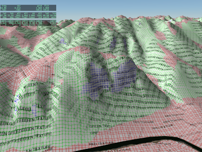
A lot of the times when I work on the rendering engine, it is with test textures like this. Our art team does their best to hide the seams between different art assets, so that the scenery looks like one continuous world. The problem for me is that the better they do, the harder it is for me to tell if the underlying shaders are doing what they should do.
So alpilotx sent this test: it’s all of the Innsbruck area painted with a test texture. What’s new and interesting here is that the flat, hill, and cliff areas are all shaded by a single shader that selects between multiple textures (and rotates the textures) based on the underlying mesh.
We are adding the cliff shader to version 10 for a few reasons:
- Often we can get better cliff and hill definition by processing in the shader than by painting different triangles with different textures; our ability to control the transitions using different .ter files is limited.
- Using one slope-sensitive shader saves over-draw and triangle count, which makes the DSFs faster and smaller.
- Some day we may have the GPU distorting mountains on the fly to make them more mountainous. If we do, we need the GPU to also apply the correct textures; if the cliff areas are precomputed then they won’t respond to GPU distortion.
If I could have a dime for every email I have received that asks some form of “will X-Plane 10 have X” (where X is a feature or enhancement), I wouldn’t need to actually work on X-Plane anymore. (If you think your email triggered this post, well, there are approximately 100 other users who have asked the same thing.)
Simply put: I have no idea and I’m not going to try to answer these questions any more. Here’s why:
For as long as I have been involved with X-Plane, Laminar Research has provided free patches to the simulator throughout a major version run, and those patches have included not only performance enhancements and bug fixes, but also major new features.
So the question “will X-Plane 10 have X” can really mean one of two things:
- Will X-Plane 10.0 have feature X immediately ‘on the DVD’?
- Will X-Plane 10.x ever have feature X in a free patch before the major version run is over.
I can answer the first question, because we are relatively locked down on what features are still on the table for 10.0 vs. what must wait, but I think it’s at best confusing to do so. If a feature isn’t on the DVD, it might be in a free patch within weeks; it might be available by the time you get your DVD. Whether a feature is on the DVD is of interest to us as we plan our release, but I don’t think it actually makes a huge difference to users with internet connections.
Consider 64-bit – it’s something we want to look at during the version 10 run but we’re not going dig into it until after we get 10.0 out. So will 10.0 be 64-bit? No. But there will probably be a 64-bit patch available for free. I think you can see why I don’t want to post “X-Plane 10 will not be 64 bit.”
I cannot possibly answer the second question, because versions run over several years, and what we code for the end of the version run will depend on market conditions and technology that don’t exist now. One of the nice things about patching X-Plane frequently is that we can revise our plans as conditions change.
Consider the question “how many cores will X-Plane 8 utilize” had you asked the question during X-Plane 8.0. When X-Plane 8.0 came out, the answer was “only one” and we had no road-map to change that. For that matter, multi-core machines were rare and exotic beasts at the time, so multi-core wasn’t a priority.
Within the three years of X-Plane 8’s major version run, we ended up supporting multi-core for scenery mesh loading, something that couldn’t have been easily predicted at the beginning of the version run.
Finally, a note on release planning: now is absolutely not a good time to ask for features. The features that will ship in X-Plane 10.0 have already been determined, and since we’d like to ship X-Plane 10 sooner rather than later, I don’t think there’s anything you can say that would make us add a feature to 10.0.
All future features are going into a 10.x “bucket” for planning purposes. Since Austin, Chris and I are up to our eyeballs in code and the art team is red-lined too, we’re not spending any time sifting through 10.x buckets right now. If you send us a feature request, the very best case is that we dump it in a holding list for later; the worse case is that we lose track of the request in the chaos.
That doesn’t mean that we don’t care about 10.x. It’s just that we are very much heads down in the 10.0 release now and won’t look up until it’s done.
I have mentioned a few of the scenery engine features coming in X-Plane 10 that will be of interest to authors: global illumination, conditional parts of OBJs (to cope with variable rendering settings). There is another general feature coming that will make authoring scenery a lot easier, I hope.
X-Plane 9’s rendering engine has the ability to drape geometry. Draped geometry are meshes that are ‘dropped’ onto the terrain and hug the underlying base mesh perfectly. The most common example of this is the runways: because the runways ‘drape’ the ground, the runway shows any curvature and bumps from the underlying base mesh. This is who we create sloping and non-flat runways.
Authors can drape geometry as well, using a draped polygon (.pol) primitive in an overlay. Such draped geometry is useful any time you want to add more “paint” to the ground, e.g. to put down a taxiway, parking markings, dirt, grass, a driveway for a house, you name it.
There is one case in X-Plane 9 where you cannot drape geometry: in an object. In an object, all geometry is aligned to the object, and will only interact nicely with the ground if you get lucky. For example, if you model a house with a sidewalk, the sidewalk won’t “sit” on the ground if the ground turns out to be sloped. You can use ATTR_poly_os to hide the artifacts, but ATTR_poly_os really can’t cope with mismatches between the OBJ and the terrain under it.
X-Plane 10 will introduce a new object attribute: ATTR_draped. Draped geometry in an object is actually draped down onto the terrain when the object is placed in the scenery. This means that the draped part of the object will hug the ground perfectly with no interference or Z thrash. You get all of the quality of a draped polygon with the convenience of an OBJ.
There are a few possible uses for ATTR_draped:
- Any time a 3-d model needs some ground details attached to it, e.g. the driveway near a house, draped geometry provides a good fit with the ground and good alignment with the object.
- Any time you want to include a pre-made ground decal (E.g. a painted parking spot on a taxiway), the ground detail can be modeled as an object using draped geometry.
ATTR_draped will facilitate creating and sharing custom details for airports and streamline the authoring process.
This is my expectation for scenery compatibility in X-Plane 10:
Scenery based on DSFs, OBJs, and other version 8/9 file formats should work with X-Plane 10 unmodified.
This includes orthophoto scenery based on DSFs – we’re not throwing that code out.
The new rendering engine features for version 10 (and there are a lot of them) are extensions – new ways to render things, new types of art assets.
I do believe that we may drop support for ENV scenery files in version 10. We’ve had DSF for six years now, and ENV’s capabilities (a 500m mesh, very limited orthophoto resolution) aren’t useful to today’s users. You can use DSF2Text/XGrinder to extract custom object placements from an ENV for use in a new overlay.
We may also drop support for OBJ version 2. (Yes, we still load OBJs version 2.) OBJ version 2 is the OBJ file format from X-Plane 6, the one before OBJ 7. If you have any old OBJs (version 2 or 700) you can use XGrinder to automatically batch convert them to OBJ8.
X-Plane 10 will have rendering options for global illumination and global shadows. This leaves one question: what if the user has these features disabled?
The plan for version 10 is this: the OBJ file format will have some extensions to allow conditional commands based on rendering settings. A few notes on these conditional commands:
- They will only be based on rendering settings.
- They will be evaluated once when the object is loaded. (If rendering settings change, the object will be reloaded.)
The idea is to be able to change which lit texture you use or remove a set of shadow polygons depending on rendering settings.
The conditionals are evaluated once at load time so that the object can be fully optimized based on the particular set of conditionals used. For example, if your drop shadow (with ATTR_poly_os) is fully removed at load time (because global shadows are on) your object now has fewer attributes, which is good for frame-rate.
This is very different from ANIM_hide. The hide animation may or may not hide depending on datarefs; to keep this fast, you cannot “hide” an attribute, only triangles. This means you “pay” for your atttributes no matter what.
The motivation for both designs is this: if the set of attributes in a file never changes (e.g. they are either conditionally removed at file load once, or they are always present regardless of animation) then we can optimize the attributes of an object once knowing how they relate to each other, to create the leanest, meanest OBJ.
This post is a bit of an experiment…we’ll see how it goes. When we cut the global scenery, we do a number of validations: we manually inspect some of the DSF tiles, we examine the Earth orbit textures (which are derived from the DSFs) as a quick way to look roughly at all of the tiles, we have a number of internal consistency checks in the generator, and we can compare our output to some of the input data (e.g. did we lose all of our water) to look for gross bugs. But we don’t have enough resources to manually examine all 18,000+ tiles in detail inside X-Plane.
So: if you have found a defect in a global scenery tile in version 9, please list the tile in the comments section of this post. I will try to give these “previously broken” tiles priority in manual inspection.
Note that the bugs we can expect in version 10 will be very different than in version 9 because we’ve really changed the global scenery generation process in nearly every important way. The underlying algorithms are heavily rewritten and data sources are very different. The goal here is to simply find areas that might have a higher probability of weirdness.
Let me try to be clear about what constitutes a broken tile and what does not. Please read this definition six or seven times before you post a comment.
- Do not report bugs of inaccurate data. If your favorite road is missing, or the coastline is in the wrong place, don’t report that here. That is not a defect in the rendering process; rather it is a limitation in the source data. I am not trying to collect a list of data inadequacies. We have already selected the new data for the new render. “Stuff is in the wrong place” is not a bug for this list!
- Really weird patterns are of interest. For example: I have seen some reports of very long thin bars of land going perfectly north along the edge of the tile, or a comb of mountain and valley, again perfectly vertical. These are bugs in the production process and I do want to know about them!
- Do not report errors in the placement of the 3-d layers (trees, roads, etc.). Since the 3-d layer is being completely rebuilt for version 10, none of these defects will be present in version 10. (They’ll be replaced with a totally new set of weird behaviors!)
- If an airport is too bumpy to use (with “flatten ” turned off in the sim), report this only if the terrain around the airport is grass. Basically the grass means that we tried to “fix” the airport in the v9 render and failed. If there is no grass (the airport is over forest or city) and it is bumpy, do not report it – that means it was added to apt.dat later.
- Do not report mismatches between the airport shape and the grassy patch; this is just the apt.dat file being updated.
If you have something to report (basically incorrect flattening of grassy airport areas and really weird coastline/terrain bugs that are clearly programming errors) please include three pieces of information:
- The DSF tile, e.g. +42-072
- The nearest ICAO of an airport near the bug (e.g. KBED)
- A very short description of what went wrong (e.g. “tall thin vertical lakes running through the entire DSF”).
Please only post defects of the above nature in the comments section of this blog post; to keep things clean I am going to nuke any off-topic comments on this post.
EDIT: see the first Squawk, Arista’s report on LOWS. This is a perfect report: it includes the DSF tile, the ICAOs, a brief but clear description, and it is a bug in how we process the data, not the data itself.
If you are planning on submitting an airport layout to Robin so that it is used to flatten terrain in the X-Plane 10 global scenery, please submit the layout to Robin no later than October 10th, 2010 (that is, 10/10/10).
If you have an incomplete but useful layout (e.g. the airport border is in place but not the taxiway signs, you can still submit it; we only consider border outlines and the pavement itself when flattening, not markings.
You do need both the border outline and all existing pavement. The reason for this is that the airport border is used to change the land class to grass, but water is only converted to land (if we have a coastline error) base on real pavement.
More info on airport layouts and how to submit data to Robin can be found here.
