Now before you come at me with pitch-forks, I don’t hate photo-realistic scenery, and X-Plane’s performance with orthophoto-based scenery is very, very good. But…the term “Photo-Realistic”…it makes me crazy. Here’s why:
First, photo-realistic scenery links the use of photographs in scenery to realism in its very name, and I don’t buy it.
Yes, some photo-based scenery packages are realistic looking, by today’s standard of flight simulation. Some are not. Just look at any old photo-realistic package to see what I mean…realistic is a relative term, defined by how much fidelity we expect, and that expectation has steadily gone up. Even with a modern package, a photo-based scenery pack might not be realistic if the photos are not used well.
(For example, is a package that uses orthophotos on the mesh but provides no 3-d in a city still considered realistic now? What kind of review would such a package get?)
Nor do photos have a monopoly on realism. They can look nice when well used, but I would put Sergio’s custom panel work up against any photo-based panel. (Sergio does not manipulate photos for his panel, he constructs them from scratching. He has thousands of photos for reference, but the pixels you see are not originally from any photo.)
Second, the term photo-realistic (in the scenery world) is most commonly applied to scenery that applies orthophotos to the terrain mesh in a non-repeating way. But orthophoto base meshes don’t have a monopoly on the use of photographs, which can be used to form land-class textures or to texture objects.
Okay, so “hate” is a strong word. But I feel some frustration whenever I see scenery discussed in terms of “photorealism”.
The rule is very simple: if you want to put a marking on the ground, your results will be much better if you use a .pol (draped polygon) or .lin (draped line) than if you use an OBJ. In fact, an OBJ is probably the worst way to put markings on the ground.
Requirements for Good Looking Markings
In order for markings to look good you need to have three things happen:
- You need to make sure your markings are at the exact same level as the ground itself.
- You need to use polygon offset to tell X-Plane to tell the video card that these are “coplanar” (at the same height) triangles that must be managed in a special way.
- You must guarantee that the draw order is: the stuff under your markings, your markings, then the 3-d buildings and other 3-d stuff.
With these requirements we can compare .pol/.lin files to OBJs:
- .pol and .lin files always “drape” to the ground, so they always meet rule 1 perfectly. With an OBJ you can set the height of your OBJ to 0 but on sloped terrain this won’t be correct.
- .lin and .pol files are always “polygon offset” automatically, so they always meet rule 2 perfectly. With an OBJ you need to use ATTR_poly_os.
- ATTR_layer_group (or LAYER_GROUP) tell the OBJ or pol/lin in what order to draw, so you can set this correctly in all cases. The default values if you don’t specify a layer group are more appropriate to the task of markings on the ground when you use a pol/lin – that is, by default they meet rule 3 perfectly. By comparison, an OBJ may not be in the right draw order.
So we can see from these 3 rules that you will always get the rules right just by using a pol or lin, but you have to be very careful and may still not get the rules right when using an OBJ.
Performance? Think .pol
When you have a large number of small markings, the performance of a .pol is going to be significantly superior to the performance of an OBJ. For example, imagine an airport where you want to draw on-pavement signs for all taxiways and runways. With an OBJ, to get the height right, you’d need to use a large number of small objects. (With one large object, it will be nearly impossible to make the OBJ markings be on the ground when far from the object center.)
When you use a large number of .pol markings that share one common texture and all have the same .pol file, X-Plane merges them behind the scene into one huge object-like pile of triangles. The cost of drawing all of those polygons will be similar to the cost of drawing just one object! That’s a huge speed win.
Floating Objects Are Wrong
What I see most commonly in scenery packs that are sent to me and have thrashing problems are OBJs that have a height other than 0. This is simply the wrong way to create overlaid geometry in X-Plane, and it will produce artifacts in a wide variety of situations. At best, the “floating” objects will cause airplanes driving over the marking to look like they “sink in”. At worst, the offset you pick will be too small for the video card’s resolution and you’ll get thrash anyway.
There is no one right vertical offset for all scenarios, and even if there was, it would still look ugly! See the above rules for what an OBJ really has to do.
How Do I Get a .pol into my scenery.
Well that is the $10,000 question. I must admit that I don’t know what Overlay Editor’s capabilities are in this regard. WED 1.1 will be able to add draped polygons, including texture coordinate editing of the polygons. I’ve been working on the texture coordinate editor in WED this weekend and am hoping to get some kind of WED 1.1 preview built this week.
With WED 1.1 the process is fairly simple:
- Create your texture.
- Create a single .pol text file that names the texture, so you can use it.
- In WED 1.1 you can select the .pol from the list of resources for your scenery pack, and then use the “polygon create tool” to simply draw the draped polygons into place.
- Once the draped polygons are created, you can select the polygon and open the “texture coordinate editor” tab to edit the way the texture is applied to the polygon.
My hope is that this process will be easier than creating markings using a 3-d editor – you can still edit the texture coordinates, but you can do so directly in WED.
I was revisiting Bézier curves today. First I should say that the current scheme for handling Bézier curves in apt.dat and DSF is horribly convoluted – I am looking to replace the syntax with something less weird for the next set of features that use them. But I was also looking at the problem of generating curves from high-density line data.
Did you know that a Bézier curve can have any number of control points? This picture illustrates:
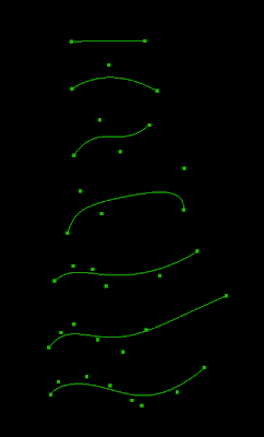
Each curve has one more control point than the last. Zero control points is of course a line segment, and two control points is a “cubic” Bézier, which is what we have now. (Note that having one control point in WED does not give you the one-point quadric Bézier you see here. WED gives you a cubic Bézier with one control point on top of an end point.)
But it also show: having tons of control points are not particularly useful for modeling a shape in detail – a string of connected cubic Bézier is probably just as good. And the high-order Bézier doesn’t really trace out the control points, so it’s not a good way to convert line segments into a curve.
Beta users, see the bottom of this post for how scalability turns into possible bugs.
In computer science, a program or architecture is scalable if it doesn’t totally vomit up a lung as its constituent parts become bigger. For a cleaner definition, see Wikipedia, source of all internet knowledge.
An ant is not scalable – if you made an ant 100 times larger in every dimension, its tiny legs would break under its new weight. (An ant is not scalable because its weight grows faster than its structural strength. Thus elephants are not built like ants.) Geeks: scalability is to computer science as marginal cost is to economics.
Before X-Plane 940, the apt.dat file was distinctly not scalable. The entire file was loaded into memory; as users created more and more taxiway lines and signs and details, we simply used more and more memory. This approach isn’t very scalable because authors have the potential to grow the apt.dat file faster than our system requirements can increase.
X-Plane 940 fixes this by not loading the entire apt.dat file into memory. Instead, only essential airport information is loaded into memory, along with a note as to where in the file the airport lives. Whenever an airport actually has to be built into a 3-d mesh while you fly, we go back to the apt. file and load the rest of the data for the one airport we are building, use it, and throw it out. Since 3-d airport meshes are built on a second core, the cost of loading one airport off disk is pretty harmless.
The problem with this fix is that it introduced a new scalability problem. Consider:
- Meshes in 940 are built on as many CPU cores as you have – some users have 8!
- Each CPU core could be working on a different airport, depending on how many are nearby.
- Each airport has to load up the apt.dat file to get the extra airport data.
This means that at times on an 8 core machine we could easily have allocated 50 * 8 = 400 MB of memory just to temporarily hold 8 copies of the apt.dat file.*
This is of course completely silly – there’s no reason to load the whole apt.dat file to get one airport, and the fix that is going into beta 8 lets the airport loader surgically grab just one airport. Thus we will be scalable again, because adding more cores won’t cause memory usage to go up.
Beta Users: Please keep an eye out for X-Plane running out of memory – if it starts to do so in the next beta it means that some part of this code change munged memory management. We’re running stress tests on the sim now, but touching the low level memory nd file handling code late in beta isn’t something I like to do.
* While loading 8 copies of the apt.dat file is wasteful of memory, it is not slow; X-Plane uses memory mapped file I/O, so reading a small part of a large file is very fast – just not very virtual-memory efficient.
I’m seeing a number of bug reports where weird artifacts are showing up in 940…missing pieces of runway, flickering triangles…all sorts of good stuff!
I believe that this is due to some kind of bug relating to threading, X-Plane and the video drivers. I won’t say whose fault it is because I really don’t know. I do know that the bug appears to not happen on OS X. (But this could simply be because the threads time out differently on OS X.)
The changes to the rendering engine for 940 from 930 are substantial and aggressive – it’ll take us a little bit to fix these things.
When you wonder how come programs don’t use all 8 of your cores yet, well…this is why…multi-core programming is complex, tricky, tedious to debug, and often involves substantial changes from the original code.
X-Plane 940 now supports normal maps on OBJ models (both scenery and airplane). I’ll get more formal docs up once the rest of my office is moved and unpacked but here’s the details for now:
The normal maps are in “blender” format see here. The alpha channel is optional; if it is present, it serves to modulate the level* of specularity. Opaque means full specularity, transparent means none. You can use this feature to make some parts of an object shiny and some dull on a per-pixel level.
Shininess level is modulated by both ATTR_shiny_rat and the alpha channel, so you need ATTR_shiny_rat 1.0 and an opaque alpha channel (or no alpha channel) to see full specularity.
Normal maps are only available for objects and only appear if pixel shaders are on and per-pixel lighting is enabled.
Normal maps should be PNG format, not DDS – they will not be texture compressed because S3TC compression tends to kill them. (There are some modern formats for normal map compression supported by the newer cards but we don’t use them yet.)
* Specular level: most serious 3-d programs let you control both the specular exponent, which controls how “tight” the specular hilights are, and the specular level, which controls how bright they are. X-Plane only lets you control specular level; if specular hilights exist, they are always as the maximum exponent for the sharpest specular hilights.
X-Plane 940 beta 1 is out…it will take a little bit to get the release notes and docs on the website completely up-to-date. We’re still dealing with loose ends from our migration to the new web site, and most of my office is packed up for a move to the Boston area. I’ll try to get docs up as fast as I can given the chaos flying about.
Given the interest multi-core stirred up in previous notes, I will mention one change to 940: with this build we’ve added yet more multi-core to X-Plane.
In 931, X-Plane will use as many cores as you have to load textures, but only one to build “3-d scenery” (a loose category for the work we do when we make airport taxiways and lines, build forests, and extrude roads).
In 940, this “3-d scenery” is also done on as many cores as you have. This should speed up load times a bit, particularly under very heavy tree settings, and hopefully keep the forest engine running faster for users with more cores.
It also sets us up for long-term growth; X-Plane’s visual quality is sometimes limited by the time to build 3-d meshes…being able to do this work on many cores means we can use higher quality algorithms.
Consider for example the roads: my original “road extruder” (the code that converts a vector road into a 3-d model, called an extruder because it builds a 3-d road from a cross section like one of those play-dough toys) made beautiful intersections with stop-lines and cross walks and lots of other great stuff.
It was also really slow. And at the time the sim wouldn’t fly at all while roads were extruded, so speed was of primary concern. So I replaced it with the much dumber extruder you see today, where intersections are basically ignored.
Now that we have 3-d scenery build on multiple cores, we can begin to provide rendering options that take more CPU time but produce higher quality results. The trees and airport layouts already do this (in that they take more time and produce slower, more detailed, higher triangle count sceneery at higher rendering setting for the same input DSF ad apt.dat file). With more cores, we can continue this strategy with roads and other parts of the sim without worrying about overloading the one core that was doing this work.
Of course just because we can use 8 cores doesn’t mean we do…you won’t see 8 cores maxed out very often, particularly if you have simple scenery and a very fast machine.
I have been working on OpenStreetMap data for X-Plane this week. Use of OSM for global scenery is going to be a bit different from projects like X-VFR or other specific custom OSM-based scenery.
The issue at hand is accuracy vs. plausibility…
- Accuracy: how much error is there between what exists in the real world and what exists in the scenery. Is that road in the right location? Is it the right type of road?
- Plausibility: does the scenery as a whole look reasonable? Is that road on land or is it in the water? Is that river running up a mountain?
The global scenery needs to prefer plausibility over accuracy. Because we can’t check and manually fix errors in the source data for the entire world, and because we don’t cut the global scenery very often, it is important that the global scenery err on the side of reduced accuracy (remember, the global scenery isn’t that accurate in the first place) rather than plausibility problems that will clearly be ugly and distracting.
The implication for OSM-based global scenery: not everything in OSM is going to show up in the global scenery. This would be true anyway simply due to the need to keep the global scenery compact. (I trust that OSM will grow to the point where it can source scenery larger than we can ship for the entire world.) But the global scenery generator may need to err on the side of not including data that might have plausibility problems.
Fortunately it is possible to build custom scenery from OSM as well. I don’t see OSM-based global scenery as replacing efforts like X-VFR and others; rather custom scenery will always be able to use more OSM data , checking the data for accuracy, rather than reducing the data to maintain plausibility.
One technical note: I am working on an extention to the road .net file format that would allow road networks to be draped over terrain. This would allow overlay packages to add/replace road grids without having to know the shape of the base scenery mesh, and make it easier to both create custom road networks and to create the tools that manipulate them.
To answer the most basic questions:
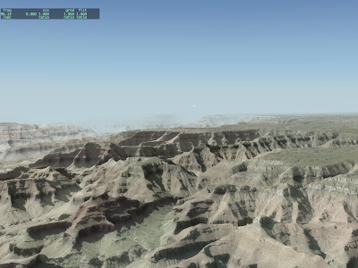
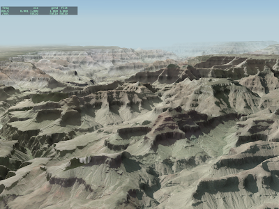
- This is a base mesh orthophoto scenery I made with MeshTool, as a test.
- The source DEM is 10m NED, the source imagery is 1mpp DOQQ, down-scaled to 3mpp. I gave MeshTool a point budget of 500,000 mesh points per DSF tile, and it used them all.
- This version of MeshTool (2.0 beta 2) should be out in the next 3 days.
- That’s X-Plane 930RC4. The framerate really is around 100 fps.
- There are no dynamic real-time shadows. Rather, the orthophotos have the shadows “baked” in because they’re photos.
- There are artifacts at the joins of the orthophotos because I spent time fixing projection errors.
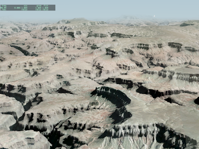
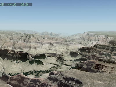
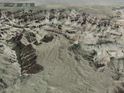
Clearly we need more than 25 nm visibility in some cases!
I have received several requests for a transparent runway with a physical surface type. That request is just strange enough that we need to look back and ask, “how did we get here?”
High Level and Low Level Modeling
The “new” airport system, implemented in X-Plane 850 (with a new apt.dat spec to go with it) is based on a set of lower level drawing primitives, all of which are available via DSF. In other words, if Sergio and I can create an effect to implement the apt.dat spec, you can make this effect directly with your own art assets using a DSF overlay. This relieves pressure on the apt.dat spec to become a kitchen sink of tiny details.
The goal of apt.dat is to make a visually pleasing general rendering of airport data. DSF overlays provide a modeling facility.
Little Tricks
It turns out there are two things the apt.dat file “does” with the rendering engine that you can’t do in an overlay DSF:
-
The apt.dat file registers runways in the airport dialog box (for starting flights, positioning the airplane, etc.).
-
When the apt.dat reader places OBJs to form approach lights, it can offset their “timing base”, which is why the rabbit flashes in sequence.
(If you were to place a sequence of approach lights with rabbits in an overlay, every single light would flash at the same time because the DSF overlay format does not have a way to adjust the object’s internal timing parameter.)
The solution: the transparent runway. The idea of the transparent runway is to create with the apt.dat file the two aspects of a runway that you can’t build with a DSF overlay: the approach lights and the entry in the global airport dialog box. Transparent runways leave the drawing and surface up to you.
My thinking at the time was that the actual runway visuals and physics would be implemented together via either draped polygons or a hard OBJ.
Orthophotos and Bumps
So why do authors want a transparent but hard runway? The answer is orthophotos. With paged orthophotos, it is now possible to simply put down orthophotos for the entire airport surface area (whether as overlays or a base mesh) at some high resolution (our runways are 10 cm per pixel – I’m not sure if the whole airport area can be done at that resolution) and not have any special overlays for the runways. The transparent + hard runway would change the surface type.
I’m not sure if this is a good idea, but I’m pretty sure that this feature belongs in overlay DSFs and not the apt.dat file.
- Such a technique (varying hard surfaces independent of a larger image) is useful for more than just airports (and certainly more than just runways).
- The technique is unnecessary unless a DSF overlay is in use.
- Unlike nearly all of the rest of the apt.dat file, such an abstraction (invisible but bumpy) is much more a modeling technique and less a description of a real world runway.
I’m not sure we would even want the runway outline to be the source of hard data. If there are significant paved areas outside the runway then a few larger hard surface polygons might be more useful.


